Check Gaps

A polygon collection that will be used to create an XFM Smart Solid must completely enclose a volume. This requires that adjacent polygons are free from gaps. The Check Gaps tool is used the check for gaps between adjacent polygons.
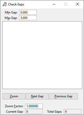
The minimum and maximum gaps are specified in the dialog. Any gaps that are larger or smaller than these tolerances will not be located. Set a gap large enough to capture any expected digitizing errors.
To check for gaps:
Adjust the Minimum and Maximum Gap values. Any gaps smaller or larger than the specified values will not be considered a gap. For a minimum gap, set a tolerance small enough to capture any gaps but large enough to not be affected by the solids modeling tolerance.

Elements can be checked individually or by selection set.
To select individually, select each element with a data point. Use the CTRL key to select multiple elements. When finished, accept he operation with a data point. Alternatively, create a selection set of the elements to be checked and accept with a data point.
Found gaps will be listed as element pairs in the dialog. The view will update with points indicating their locations. The element pair currently selected in the dialog will be highlighted.

Zoom in on the selected gap by choosing Zoom In.

To close gaps:
Close gaps by using MicroStation editing tools such as Modify Element. Each pair of elements may have more than one gap between them. Use the Next Gap and Previous Gap buttons to move between the gaps needing investigation and correcting.
Key-in: 3DSMARTEDITING CHECK GAP